Once the Portuguese entered the Indian Ocean, Spanish, French, Dutch and English seafarers all tried to locate the fabled Southland or Terra Australis Incognita. Many thought they had found it. Not realising that Dirk Hartog and his compatriots had already encountered and mapped parts of Terra Australis, Abel Tasman sailed from Batavia (now Jakarta) to explore the Southland. He charted the coast, joining all the previous Dutch discoveries into what he called New Holland. For well over a century explorers still sought the Great South Land including William Dampier and James Cook. Not to be out done by their English rivals, French mariners such as Yves-Joseph de Kerguelen-Tremarec and Louis de Saint Aloüarn also ventured into the southern Indian Ocean looking for Terres Australes. It was not until the voyages of Nicolas Baudin and Matthew Flinders that the mystery was solved. Terra Australis Incognita, the Great South Land, was Australia.
First Map of Australia (1547)
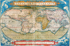
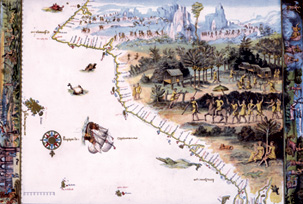
1856 Nicolas Vallard 1547 This is a copy of an original manuscript map of Java-Le-Grande, first produced in 1547. One of fifteen maps of the known world appearing in the Vallard Atlas, it is from the ‘Dieppe School’ of French cartography. This group of map makers used information from French explorations and borrowed heavily on the work of other European nations especially the Portuguese. North is to the bottom. Some suggest that this landmass depicts the eastern coastline of Australia and was a result of the explorations made by Cristóvão de Mendonça. In 1521, King John III sent him to claim new lands for Portugal before Ferdinand Magellan could do the same for Spain. Hailed in 1856 as ‘The First Map of Australia’, it was seen as an affront to the achievements of Captain James Cook RN, the theory being that it represents Cape York (bottom right), New South Wales and Port Phillip Bay (top right) has been hotly debated ever since. Original on loan courtesy of the Jock Clough Collection. |